Showing posts with label bikeway. Show all posts

Saturday, 26 January 2013

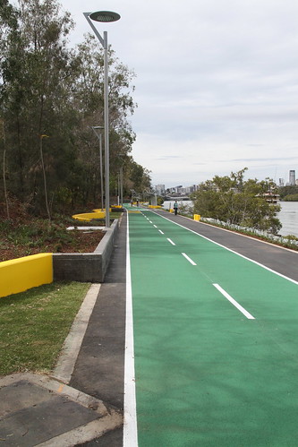
Bicentennial - Stage 3 begins

Image sourced from biking brisbane
http://www.brisbanetimes.com.au/queensland/plan-to-satisfy-hungry-thirsty-cyclists-20130121-2d23a.html

Construction on Stage 3 of the Bicentennial Bikeway upgrade has finally begun and it is to be welcomed. While it will mean 6 months of construction and slight inconvenience the results will be worth it.

Stage 3 is no doubt the trickiest part of the upgrade so far. At this point the bikeway runs between Coronation drive and the former Drift Restaurant on the river. This makes what is already a very narrow corridor to upgrade at the narrowest point into a contemporary Active Transport arterial even more challenging. To make it possible part of the bank supporting Coronation Drive is going to be partly dug into and the pedestrian path will go hard up against the former restaurant. As well as this the notorious bridge just before the restaurant is going to be duplicated so that each mode has it's own bridge. Then there is the ground which is terribly unstable, so much so that is to be stabilised with piling work so it doesn't fall into the river. All in all it is alot of very tricky work for a mear 520meters of upgrade but I can honestly see where the $8 million is going.

Stage 3 is sandwiched in between stage 1 & stage 2. This has currently resulted in the confusing situation of the path going from segregated to shared and back to segregated. At the moment it is the bottle neck on the corridor with the notorious bridge being the pinch point. After the works are completed Brisbane will finally have a Active Transport arterial that will extend from Land St Toowong into the CBD. While this will mean only 3 kms has been built to contemporary standards it is an important 3kms. It will mean the thousand plus bicycle movements coming from the Western Freeway Bikeway will be catered for with no need for mixing it up with pedestrian movements.

Since the upgrades to the Bicentennial Bikeway began back in 2009 use has jumped from over 4000 bicycle/pedestrian movements to now over 5500 movements a day. This is indeed an impressive figure as it shows that there has been a 30% jump in just 3 years. This has to be put down to the upgrades, as figures I have sighted showed before the upgrades begun Bicentennial had reached a plato where use had dropped in 2005 only to bounce back in 2006 with the opening of the Western Freeway path to Jindalee. Once Stage 3 is completed further increases in usage will surly occur due to the removal on the main pinch point. It will be interesting what the patronage of  Bicentennial will be this time Next Year.

Once Stage 3 is finished bring on the final Stage, Stage 4.


Wednesday, 16 January 2013

Sexism? Bicycle Infrastructure

http://www.brisbanetimes.com.au/national/sexism-behind-overinvestment-in-cycling-infrastructure-report-20130111-2cl7q.html
According to a article that was published on the weekend on Brisbane Times cycling infrastructure can be seen as sexist. The validation of this claim is due to the fact that the majority 75-80% of all cyclists are male just like the majority of elected officials. I have to say while I do not agree with the statement I can understand the premise of the argument.

There is no doubt that men out number women on bikes but I like many believe this is due to the type infrastructure that is being provided not cycling itself. Naturally this relies on some assumptions based on the behaviour of the different sexes. The (generalised) fact is men are more risk taking and have less of concern of personal safety. Then there is the (generalised) fact that men see many activities as a competition, women may not have this opinion. While this is a generalisation the two sexes behaviours do differ and as such women are more likely to ride flat bar bikes designed more for comfort on there commutes then drop bar bikes (see upcoming bikeways count post). This means what some male policy makers may see as good will be scene in more of a discerning image by a female.

A good example of good and moderate to bad on the same corridor (western) is the Bicentennial Bikeway and the Sylvan Rd Bike lanes. These two pieces of infrastraure link the Western Freeway Bikeway to the Brisbane CBD and form the Western Cycling Corridor.
The Bicentennial Bikeway is separated segregated Bicycle Arterial that allows anyone riding along it to ride at there own pace in complete safety without fear of a oncoming car or random car door carelessly slung open in front of you.
This is in contrast with Sylvan Rd (that is still part of the main corridor) which has bikelanes that sometimes are hard up against cars and have cars turning across the bikelanes at the lighted intersection. On this Bikelane you can not ride at your own pace you feel like you have to go flat out as there is not space for another bike rider to overtake you without them having it to mix it up with motor vehicle traffic. This need naturally leads people desiring to ride a faster type of bike, not the kind of bike (flat bar) that is favoured by females.

The fact is cycling is not sexist but the infrastructure does needs to be more designed around people being able to ride at the speed they wish to travel at. This means on major corridors segregation is the key to getting more females in the saddle. The former Floating walkway was an excellent example of separated (from cars), encouraging females on to bikes. Basic observations would guess that women made up far more than 20% of people riding along it. This is because it allowed anyone to ride at a speed that they felt was comfortable. It also meant that the bike shop serving the area has next to no drop bar bikes in the store but is populated by flat bar and city bikes.

So why is the existing separated infrastructure not performing better. For this just look to the example I gave, an arterial is as only as good as the feeder/link. Without this link/feed relationship it stands out and the potential effect is limited. This does not mean each feeder route needs to be to the same standard as the arterial but it does mean treatments such as traffic calming that make the feeders safer and more comfortable to on ride be installed. Arterial and feeder system is how motor vehicle artierals work and so it should be for bicycle infrastructure.

Monday, 15 October 2012

Centenary Bikeway Axed - further condemnation


To the great surprise of many, Bicycle Queensland came out with this statement on Thursday.
BQ seeking meeting with Minister over axed bikeway
11 October 2012
Bicycle Queensland is seeking a meeting with Transport Minister Scott Emerson to discuss the axing of a bikeway from Richlands to Springfield.
Bicycle Queensland Manager Ben Wilson said the deletion of the planned bikeway would lead to more people driving, fewer people cycling and less safety for people riding bicycles.
“We are concerned with the severance of the Springfield community from the existing bikeway network, local and longer destinations including Oxley, Indooroopilly, Toowong and Brisbane CBD due to the loss of a safe crossing of the Logan Motorway,” he said.
A popular Cairns bikeway is also under threat - Bicycle Queensland is dismayed at the unacceptable and retrograde proposal to remove part of the State and Cairns Council funded Aeroglen bikeway for car parking.
 
Why was this surprising? Well in most cases BQ almost never says a bad word against any level of government. The fact that BQ has publicly said something must mean they must be upset.

On top of this "Rail Back on Track" a lobby group for better public transport has also been critical. See this quest article. This has been taken from there media release in which is stated
The planned bicycle/foot path linking Richlands and Springfield has been discarded in favour of a road upgrade. Without the bike-way and with the extra road lanes, the Centenary Highway will reach its capacity more quickly."

"Rather then address the real basis for congestion, too many people travelling in cars, they have chosen to further worsen congestion by also not optimising the railway presently being constructed from Richlands to Springfield."
And this is the truth. Congestion is this area is being caused by to many cars. People have no choice but to drive and fill up the roads.  The original plan of a multi-modal corridor needs to be reinstated where Bike, Road & rail is all built along side each other to give people a real choice.
 

Wednesday, 12 September 2012

QLD State Budget - day after

http://www.runningmaps.eu/spip.php?article44

I would first like to disclose that I find reading State Government Budget Papers very difficult.

According to the Governments own Media Release there is to be "$102 million Cycle network grants and capital programs" This looks all very encouraging until you start to wonder what the "and" is there for and weather or not capital programs are cycle programs or something other. I have looked in the Budget Paper 3 - Capital Statements for this $102 million and I can't find it. In fact the word cycle only appears twice in that document & only once when referring to bicycle infrastructure where it states "$16.4 million to for the development of regional cycle networks in South East Queensland". I am confused. groannnnnnnnn


Then there is the Transport & Main Roads Papers which state that last year 45kms of bikeway infrastructure was to be delivered but in fact only 20kms was put down. Then it states that this financial year they expect to lay 35kms. Now if you subtract the 25kms that was missing from last year that only means 10kms is to be laid ontop of what is a backlog from last year. This is not very much when you consider the distance between Brisbane and Cairns is near 1600kms.

This is all on top of the fact that 1 in 6 Transport and Main roads staff are to be dismissed from that department. According to the CBD BUG website twitter feed this includes staff in the cycling programs area.

On top of this according to the Courier Mail the worlds largest travel pattern change program Travelsmart is to be canned. This program informed people on how they could get about without using a car and was accepted to be successful at this. It is true it did give away backpacks which the now Government says was the only thing it was successful at. I would really like to understand how it failed because the graphs I was shown years ago said that it was working and working well.

With all the talk by the Government about how the they had to tighten the budget some how the Roads budget has yet again increased. I have to say I am less then impressed.

All in all I am less then impressed. Finding detail is very hard and the details I have found fill me with very little, for the coming year. The project I was most looking for was the Northern Cycleway but I am yet to find the word "Cycleway" anywhere in the documents. Another year another Road focused budget. Time to roll over and pretend it isn't happening.

To make me feel better here is a link to what maybe some of us will have resort to.
http://yehudamoon.com/20080319/


Tuesday, 28 August 2012

Riverwalk (former floating walkway) - Preliminary Design Released

Image sourced from www.brisbanetimes.com.au

To may great surprise last week the Brisbane City Council released it's preliminary design for the replacement to the former floating walkway now just being given the title of Riverwalk. According to council the preliminary designs offers
 
  • a more flood-resilient structure, designed to last for 100 years
  • a rotating opening span to allow for the passage of vessels to and from moorings
  • a new alignment that will take users further out into the river for the majority of the walkway, to improve the river experience and increase privacy for residents
  • a segregated pedestrian and cycle path, 2.5m and 3.5m wide respectively
  • shaded rest and viewing areas at various locations along the walkway

There must be little doubt that a fixed structure would be more flood resistant.
One interesting change from the concept drawings is the swing section to allow for vessels to access property moorings. This was originally to be a lift bridge but I have to say I personally prefer the swing design. It will be a bit more dramatic and interesting when a boat is moved in or out (a once a year event if your lucky). I am particularly interested how the joins between the swing and permanent sections will be treated.

I have to say when it comes to the structure being further out in the river, I don't care! I would have to say this would be more than likely the opinion of most of the people who will use it day in day out in there commute. This movement out has more to do with the privacy of residences then "improved river experience". That said the Zig Zaging at the Howard Smith end of the structure is a little strange. Corners are not a bike riders friend I do hope these are eased into bends.

THANK YOU! Common sense has prevailed and the replacement structure is to be designated as pedestrian one side and cyclist the other. At 2.5m to pedestrians and 3.5m to cyclists there should be little conflict if everyone behaves themselves. This will make the path a total of 6m wide only 1m wider then the previous shared path at 5m wide. This will make a world of difference as the old path was becoming quite uncomfortable for all concerned during peak usage times. Breaking the modes apart will mean that the carrying capacity of path will hopefully exceed what will ever be required of it.

Shade Rest Areas I have to say are welcome additions. The former floating structure had some rest areas however they were not shaded resulting in no one really using them. It was more like a roasting area in summer then a rest area. Adding shading will mean people will truly be able to rest.

Both Brisbane TimesThe Courier Mail had articles to read. Thankfully the Courier had it's comments bar turned off meaning that every out of town bogan was denied the chance to stir the pot.

That all said it does not look to bad but more detailed drawings need to be provided so we really know what we are looking at and getting.

http://www.brisbane.qld.gov.au/traffic-transport/roads-infrastructure-bikeways/bikeway-and-pathway-projects/Riverwalk-replacement/index.htm

http://www.brisbane.qld.gov.au/traffic-transport/roads-infrastructure-bikeways/bikeway-and-pathway-projects/Riverwalk-replacement/index.htm

http://www.brisbane.qld.gov.au/downloads/traffic_transport/roads_infrastructure_bikeways/riverwalk_preliminary_project_plan_opening_span.pdf

Wednesday, 8 August 2012

Shared Paths/Bikeways - Wider is not always better

I have previously posted about a shared path that does not work, the Pyrmont Bridge in Sydney. At the time I point out it failed on three points I consider important for a shared path to work.
  • a daily usage somewhere below 4000 movements a day
  • a path where it is not generally wider then 4 meters
  • low tourist numbers
  • clear understanding of keep left rule
  • equal split between bicycles and pedestrians
Most of the time shared paths are rather narrow (around 3 metres) and have a lower usage. This make there purpose as shared suitable. Often after a certain amount of time usage does increase and the logical solution is to simply widen the path. I have to say this is logical and does work to some extent but the problem is human behaviour is not always to the same logic. The photos below show why making the path wider to increase capacity does not always work. The below photo was not taken at a busy time but it does show some peoples bahavour.


Both photos are of the same three women walking along the Shared Riverwalk Path in New Farm Brisbane. The first is on the new section where the clear width is around 6 meters. The second is on the older section where it is around 4 meters clear. Both photos show how the logic of widening a shared path past a certain point fails. People logically when given extra space just spread out even when there is clear signage saying not to block the path and keep left. On both the 6 meter section and the 4 meter section the three women's walking position is almost identical it is just the space between each individual that has changed. This is when segregation comes into importance, because given the space (approximately 5 meters) , no amount of widening will change the way some people act and they will just spread out. Ofcourse putting down a dividing line does help to some point but is really just band aid when segregation is the most sensible option where space permits.

Thankfully most people that use this path do not act like this but it is not uncommon. This path is heavily used and the short sighted option of making it shared and to narrow (just) to allow segregation to occur has resulted in a congested environment, mostly on the weekends.  While shared paths are always an option and a good option, there ability to be widened and upgraded to segregate needs to be considered and and considered very carefully because for some people no amount of signage will help the situation.

Monday, 6 August 2012

Bikeway Counts - July - What Tour de France effect?

The bikeway counts for July are in and in the most part they are not in all that surprising.

The counts were again conducted during a 40 minute bracket of peak hour on the
  • Kurilpa Bridge - Monday
  • Goodwill Bridge - Tuesday
  • Bicentennial Bikeway - Wednesday
  • South East Bikeway - Thursday
  • Normanby Ped/Cycle Link - Friday
The thing that was of no great surprise was that apart from Kurilpa Bridge most other count locations showed not real difference in count numbers. Now this begs the question where is the Tour de France affect that the tabloid media always goes on about after the race. There is the usual complaints of Lycra clad middle age men swamping roads and getting in the way of everyone. If this is indeed true it certainly ain't happening on Brisbane's Bikeway's and it certainly ain't happening during peak hour. If there was indeed this affect it should of spilled over into the counts but it hasn't. Most count category's stayed mostly the same except for women overall. Overall women/men share of the count dropped from a ratio of 1/4 to 1/5 on the whole. Not a good sign but this may be put down to the winter weather.

The surprise result was Kurilpa Bridge jumping from 97 bikes in May to 114 in July. While this may have something to do with the count being conducted 10 minutes later to bring it in line with the rest of the counts (excluding Bicentennial) it does represent a jump of around 20%. It will only mean something substantial if the next count is also of a similar number next time but it is encouraging when all the other counts were almost stagnant.

Oh well it will be good to see what August will net as that will be the final month of Winter in Brisbane!If Brisbane is truly to hot to ride in, the Winter months should see numbers swelling but so far that is not the case.


Kurilpa Bridge Count 20120723

Time = 7:25-8:05am
Total = 114

Sex
Male = 94 (82%)
Female = 20 (18%)

Bike Type
Road = 48 (42%)
Other* = 66 (58%)

Bike per Sex
Male Road = 44 (46%)
Male Other* = 50 (54%)
                        5 citycycle included
Female Road = 4 (20%)
Female Other* = 16 (80%)

* = any bike that is not fitted with drop bar Handle Bars

General Note
-                      Not all bikes passing were able to be counted
-                      This count did not include pedestrians
-                      This count includes cyclists going both North and South
-                      Due this count occurring 10minutes later than the original figures are not directly comparable.
-                      This count was conducted at the peak of the bridge
-                      The weather was clear skies and cool temperature.


Goodwill Bridge Count 20120724

Time = 7:25-8:05am
Total = 374

Sex
Male = 310 (82%)
Female = 64 (18%)

Bike Type
Road = 162 (43%)
Other* = 221 (57%)

Bike per Sex
Male Road = 143 (46%)
Male Other* = 167 (54%)
                        2 citycycle included
Female Road = 19 (30%)
Female Other* = 45 (70%)
                        2 citycycle included

* = any bike that is not fitted with drop bar Handle Bars

General Note
-                      Not all bikes passing were able to be counted
-                      This count did not include pedestrians
-                      This count includes cyclists going both North and South
-                      Due to this count beginning 10minutes later then the Bicentennial count the figures cannot be directly compared.
-                      This count was conducted at the peak of the bridge
      -             The weather was clear skies and cool temperature.

 
Bicentennial Bikeway Count 20120725

Time = 7:20-8:00am
Total = 445

Sex
Male = 376 (83%)
Female = 69 (17%)

Bike Type
Road = 211 (47%)
Other* = 234 (53%)

Bike per Sex
Male Road = 198 (53%)
Male Other* = 178 (47%)
                        5 citycycles included
Female Road = 13 (39%)
Female Other* = 56 (61%)
                        4 citycycles included

* = any bike that is not fitted with drop bar Handle Bars

General Note
-                      Not all bike passing were able to be counted
-                      This count did not include pedestrian
-                      This count includes cyclists going both east and west
-                      This count was conducted just west of the Hale Street Bridge with counter sitting in the shade under the Overpass
-                      Between 30-50% of road cyclists were in groups or seamed to be out riding for exercise and not commuting
-                      Due to the count was conducted 5 mins earlier than previous counts and is not directly comparable
-                      The weather was clear skies and cool to brisk temperature


South East Bikeway Count 20120726

Time = 7:25-8:05am
Total = 210

Sex
Male = 169 (80%)
Female = 41 (20%)

Bike Type
Road = 69 (33%)
Other* = 141 (67%)

Bike per Sex
Male Road = 56 (33%)
Male Other* = 113 (67%)
Female Road = 13 (32%)
Female Other* = 28 (68%)

* = any bike that is not fitted with drop bar Handle Bars

General Note
-                      Not all bikes passing were able to be counted
-                      This count did not include pedestrians as they are not permitted on the bikeway
-                      This count includes cyclists going both North and South
-                      Due to this count beginning 10minutes later then the Bicentennial count the figures can not be directly compared.
-                      This count was conducted under the Vulture St overpass
-                      The weather was clear skies and cool to brisk temperature.

 
Normanby Ped/Cycle Link Count 20120727
Time = 7:25-8:05am
Total = 104
Sex
Male = 85 (82%)
Female = 19 (18%)
Bike Type
Road = 33 (32%)
Other* = 71 (68%)
Bike per Sex
Male Road = 30 (35%)
Male Other* = 55 (65%)
Female Road = 3 (16%)
Female Other* = 16 (84%)
* = any bike that is not fitted with drop bar Handle Bars
General Note
-                      Not all bikes passing were able to be counted
-                      This count did not include pedestrians
-                      This count includes cyclists going both North and South
-                      Due to this count beginning 10minutes later then the Bicentennial count the figures can not be directly compared.
-                      This count was conducted at the southern end of link were it joins Parkland boulevard
-                      The weather was clear skies and cool temperature.

Tuesday, 31 July 2012

Brisbane Bikeways - Mapped by Google

http://ten.com.au/ten-news-brisbane.htm?movideo_m=209939

So the global multinational Google, BQ and Brisbane City Council have joined together to integrate cycling into google maps as can be seen in the above TV news report. For too long cycling has been left off many trip planning tools making it hard for many people to work out what to do when wishing to access an area they are unfamiliar with or to begin riding a bike to as a form of transport.

I have to say I welcome this as something to expose people to another transport option. The first thing I notice when using it is the colours. Bright green is an offroad bikeway, while a faded green is a onroad bikelane. These are very important but unfortunately you have to work this out for yourself as on the screen it does not show this. Next is the green dotted lines I think this is to represent BAZ (bicycle awareness zone) but again I can't see a description. Apart from that it is typical google maps with blue showing you a route.

I have to say I have had a play with it on routes I know I would use and wouldn't use. I have to say on face value it is not the worst I have seen. That said some of the suggested routes I would say are taking you on very busy roads to avoid an extra km or two on a dedicated path or over a steep hill instead around it. My favourite is being told I should ride on Sandgate Road if wishing to access Shorncliffe from Brisbane CBD. Sandgate Road is a heavy arterial road in Brisbane's North and while it does have a onroad bikelane I have to say it is not one I would want to use unless I really have to. Personally I always use the boondal Wetlands instead, it is safe and fast if not just a bit longer. A similar thing happened when I tried the CBD to UQ (university of Queensland) it sent me up Annerley Road instead of along the active transport arterial that is the Bicentennial Bikeway.

That all said the map is dynamic with you being able to pull points of the map over to where you would prefer to ride. In most cases this worked fine except on the Shorncliffe to CBD Route where it would just not give up on me having to use Sandgate Rd.

All in all it is welcome addition and something that I hope will encourage more people to ride as part of there everyday activities.

an additional Brisbane times story can be found here


Monday, 25 June 2012

Brisbane City Council Budget 2012 - Bicentennial Bikeway

Due to the Brisbane City Council Budget being lite on detail like most Government budgets it is often hard know what governments (this case councils) are doing. For this reason it is hard to look at the entire budget so it is easier to look at parts of the Budget that can be defined.

In the Budget Papers on page 196 within the Appendix of schedules there is funding for the completion of the Bicentennial Bikeway Upgraded from a shared path to a segregated path. This is an important project that began back in 2009. This is highlighted by the fact that there is currently over 650 cycle movements along the bikeway between 7am - 8 am peak weekday mornings alone. Within the papers 3 projects are listed as for the Bicentennial Bikeway, stage 3, Stage 4 & stage 5. All stages can be seen at this link.

Stage 3 is the current bottle neck. Located between stage 1 & 2  it has meant the reconvergence of pedestrians and cyclists limiting the usefulness of the existing upgrades. It has been a source of problems since the other upgrades occured as large numbers had to mix it up with some pedestrian and cyclists not understanding the concept of a shared path. There is also the fact that it is sandwiched between Coronation Drive and the former Oxleys restaurant & straight after the restaurant there is a small creek to cross. Funding for this section is listed at $6.7 million. Considering how much the other sections have costed to upgrade this figure sounds about right but it should be noted like previous funding towards the Bicentennial it is more than likely half the funds are also coming from the state.

Stage 4 will mean a continuous segregated path between the CBD and Towong. Like stage 3 currently cyclists and pedestrian have to reconvergence. While this has been limiting to corridors capacity it has less of an effect as many users have already exited at the Land St Tunnel. That said it will still be welcome as it should resolve the current problems of people being confused by the change from segregated to shared then back to segregated.  With Funding of stage 4 at only $850 000 it would be safe to say this may only include commencement of works and not the whole section. It may be a project that will run into 2013 financial year.

Stage 5 is quite intriguing. I have never heard of it. It has been given $100 000 and has been placed under the investigation section.

I have to say I am glad for this funding. Once stage 3 & 4 are complete there should be very little complaint in the media of the Bicentennial Bikeway anymore. Most conflict on the bikeway should be removed with capacity for around 2000 cycle movements in each direction per hour. This will mean that a single lane of the Bicentennial Bikeway will have more capacity then a single lane of the Coronations Drive at far less of a cost.

I will leave you with some You Tube footage showing Stage 2 after it was complete
footage is not my own

Thursday, 14 June 2012

Sydney Cycleways - George st

http://www.cityofsydney.nsw.gov.au/Council/OnExhibition/CyclewayGeorgeStreetRedfern.asp

There is no doubt in my mind that the Sydney City Lord Mayor Clover Moore is one gutsy lady. She has been under sustained media attack for her determination with the installation of segregated on road bikeways. This is all about to begin again with the conclusion of consultation of the George St Cycleway.

The strange thing regarding the cycleways in Sydney is that the most controversial cycleway have not been one of the CBD cycleways but the first to run through Inner city suburbia, the Bourke St cycleway. To me this seams completely bizarre but it is the way it is. The main complaint seamed to stem around the fact that to make the Bourke St Cycleway work over it's 3.2 km length there was to be a lost of around 60 car spaces. To me this very little as it equals around a lose of around 6% of the street frontage to car parking.

The George St Cycleway is no different. Just like the Bourke St cycleway it runs in Inner City Suburbia in fact it is just 700m to the west of the Bourke St Cycleway & the main complaint regarding the cycleway again is around the removal of some parking to make it work. This has been outlined out in this article. This is currently being heavily debated on the Sydney cycling forum Sydney Cyclist.  In the debate some very interesting facts are coming up regarding the people that are complaining about the removal of the car spaces so I strongly suggest you look at the links.

I would like to preface this next bit that I do not fully understand the area in question but have looked at it with the help of the Internet. My profession is as a drafter and as such I not only love looking at plans and maps but I can quickly and easily understand them. I have looked at the plans that the council have released and I love it. To me they make sense and I see no problem with them. Yes there is the lose of some car spaces but some things have to change to fit in a new transport corridor. The new cycleway is to be around 2kms long and will run along George Street between Cleveland St & Bourke St (not the Bourke street cycleway as that has not got that far yet). The street in this distance goes from units and terrace houses to light industrial. This means that there will be trip generators at both ends of the cycleway. A very important thing when making an active transport corridor. At the City end (Cleveland st) the cycleway links into and existing shared path through Prince Albert Park that will then link to the CBD cycleways such as Wentworth Av Cycleway that then links into the Collage St Cycleway. All in all this cycleway is not a stand alone cycleway but like other cycleways is forming and network that will allow most people to get where they want on a bike.

From looking at plans I think the new George St Cycleway will be a success just like the Bourke st cycleway. I know there is a serial Youtuber that continues to post footage saying the Bourke St is not being used (he uses the same footage over and over and over etc etc). He has in fact flooded you tube with his garbage. All I have to say is don't believe him. I have been to Bourke St Cycleway myself during peak hour and seen people using it. For that reason I submit these pictures I took during March and the councils own video data.

I have to say I look forward to seeing the commencement of the George St cycleway and all I can say is go Clover! Now if only Brisbane's Lord Mayor Graham Quirk would do the same to our George St. Hummm

Trying you find this clip was made very hard because there is so much junk that has been posted by that serial Youtuber. But I found it that is the main thing.

It should be noted that in all the pictures there is always more than just a few cyclists in each photo. These were taken within only about 2 minutes as I only went up to have a quick look. Don't believe everything you see on Youtube.


Thursday, 31 May 2012

Shared Paths - Pyrmont Bridge Sydney

http://www.smh.com.au/nsw/peak-hour-in-pyrmont-bike-lanes-for-the-bridge-20120530-1zi1j.html

I would like to say right at the start Shared Paths do work but they have there limitations. There are many shared paths in Brisbane that work completely fine but they have some defining features that make them work.

Features That make a shared Path work in my opinion
  • a daily usage somewhere below 4000 movements a day
  • a path where it is not generally wider then 4 meters
  • low tourist numbers
  • clear understanding of keep left rule
  • equal split between bicycles and pedestrians
While I will in the future talk about Brisbane shared paths a Shared Path that does not work in my mind is in Sydney. This Path is the Pyrmont Bridge. This bridge was a turned over to pedestrian and bicycle usage many years ago. The main problem I see with it is that it breaks all 5 points I list above.
  • there is well over 4000 movements a day
  • the bridge is well over 12 metres wide
  • there are tourists wondering everywhere not really aware of there surroundings
  • NO ONE keeps left
  • the is not a equal split
This results in chaos with everyone ducking about. Every time I go down to Sydney I am amazed at how crazy it is across that bridge. I have turned to my other half over and over and said "this bridge needs a bike lane".

Now I am no friend of the Pedestrian Council of Australia, and like many Australians that ride bikes have no time for them or there head. That said I have to agree with them calling for a bike lane across the Pyrmont Bridge. A bike lane makes scene because it will allocate space to each group just like it does on the Bicentennial Bikeway is Brisbane. Personally I don't think the ped council is calling for this to make life easier for cyclists and pedestrians, I think they have admitted partial defeat with there calls to have shared spaces removed. Lets face it they did not have much chance on the Pyrmont Bridge with over 2000 bicycle movements a day.

See video below

Monday, 28 May 2012

Bikeway Counts

Once again I have got some figures from peak hour bikeway counts. Like always these figures are quite interesting as they are broken into groups compared with the figures that come from the government which are just raw bulk numbers. While these numbers by no means show how many people overall are using the Bikeways like the government figures do they give a feeling of who is using in what proportions.

This time the counts have included 5 links into the CBD
  • Bicentennial Bikeway
  • South East Bikeway
  • Normanby Ped/cycle Link
  • Kurilpa Bridge
  • Goodwill Bridge
The first thing that stands out with these figures is that Bicentennial Bikeway is the busiest corridor out of them all. The figure given equals to 11 bikes every minute passing the counter. It is also the only bikeway where road bikes near making up half the traffic. This easily brakes the stereotype that commuters have to ride road bikes.

Another thing that stands out from these counts is the low number of women riding bikes. In the Queensland Government own document "Queensland Cycling Strategy 2011-2021" it clearly states that men out number women 4 to 1. What is depressing about these counts is that these figures are reinforced. It would be expected that on separated infrastructure as where the counts occurred the proportion of female cyclists may be a fraction higher but unfortunately no. It has to be said just like in the document, Brisbane is lacking safe cycling infrastructure as women cyclists are the clearest indicator of that. In the Netherlands women account for 55% of people riding bikes because they are and feel safe.

The biggest surprise of the counts is the Kurilpa Bridge. While a heavily used bridge and the newest of the two Ped/cycle Bridges the bicycle numbers were quite low. These could of been due to the count occurring on a Monday or due to the count starting a little to early in the morning as apparently it got busier as the count went on.

It will be good to see what the next count may bring in figures are the chill of winter has finally reached Brissy and single figure night temperatures are once again beginning to set in.

Bicentennial Bikeway Count 20120516
Time = 7:20-8:00am
Total = 452

Sex
Male = 360 (80%)
Female = 92 (20%)

Bike Type
Road = 195 (43%)
Other* = 257 (57%)

Bike per Sex
Male Road = 175 (49%)
Male Other* = 185 (51%)
                        8 citycycles included
Female Road = 20 (22%)
Female Other* = 72 (78%)
                        6 citycycles included

* = any bike that is not fitted with drop bar Handle Bars

General Note
-                      Not all bike passing were able to be counted
-                      This count did not include pedestrian
-                      This count includes cyclists going both east and west
-                      This count was conducted just west of the Hale Street Bridge with counter sitting in the shade under the Overpass
-                      Between 30-50% of road cyclists were in groups or seamed to be out riding for exercise and not commuting
-                      Due to the count was conducted 5 mins later then previous counts and is not directly comparable
-                      The weather was clear skies and cool to brisk temperature
 
South East Bikeway Count 20120517
Time = 7:25-8:05am
Total = 223

Sex
Male = 180 (81%)
Female = 43 (19%)

Bike Type
Road = 73 (33%)
Other* = 150 (67%)

Bike per Sex
Male Road = 63 (35%)
Male Other* = 117 (65%)
Female Road = 10 (23%)
Female Other* = 33 (77%)

* = any bike that is not fitted with drop bar Handle Bars

General Note
-                      Not all bikes passing were able to be counted
-                      This count did not include pedestrians as they are not permitted on the bikeway
-                      This count includes cyclists going both North and South
-                      Due to this count beginning 10minutes later then the Bicentennial count the figures can not be directly compared.
-                      This count was conducted under the Vulture St overpass
-                      The weather was clear skies and cool to brisk temperature.

 
Normanby Ped/Cycle Link Count 20120518
Time = 7:25-8:05am
Total = 105

Sex
Male = 82 (78%)
Female = 23 (22%)

Bike Type
Road = 41 (39%)
Other* = 64 (61%)

Bike per Sex
Male Road = 34 (41%)
Male Other* = 48 (59%)
Female Road = 7 (30%)
Female Other* = 16 (70%)

* = any bike that is not fitted with drop bar Handle Bars

General Note
-                      Not all bikes passing were able to be counted
-                      This count did not include pedestrians
-                      This count includes cyclists going both North and South
-                      Due to this count beginning 10minutes later then the Bicentennial count the figures can not be directly compared.
-                      This count was conducted at the southern end of link were it joins Parkland boulevard
-                      The weather was clear skies and cool temperature.

Kurilpa Bridge Count 20120521
Time = 7:15-7:55am
Total = 97

Sex
Male = 74 (76%)
Female = 23 (24%)

Bike Type
Road = 36 (37%)
Other* = 61 (63%)

Bike per Sex
Male Road = 27 (36%)
Male Other* = 47 (64%)
                        4 citycycle included
Female Road = 9 (39%)
Female Other* = 14 (61%)
                        1 citycycle included

* = any bike that is not fitted with drop bar Handle Bars

General Note
-                      Not all bikes passing were able to be counted
-                      This count did not include pedestrians
-                      This count includes cyclists going both North and South
-                      Due to numbers increasing latter during count, future counts will be conducted at a later time in the future (approx. 10min).
-                      This count was conducted at the peak of the bridge
-                      The weather was clear skies and cool temperature.

Goodwill Bridge Count 20120522
Time = 7:25-8:05am
Total = 388

Sex
Male = 316 (81%)
Female = 72 (19%)

Bike Type
Road = 146 (38%)
Other* = 242 (62%)

Bike per Sex
Male Road = 125 (40%)
Male Other* = 191 (60%)
                        4 citycycle included
Female Road = 21 (29%)
Female Other* = 51 (71%)
                        2 citycycle included

* = any bike that is not fitted with drop bar Handle Bars

General Note
-                      Not all bikes passing were able to be counted
-                      This count did not include pedestrians
-                      This count includes cyclists going both North and South
-                      Due to this count beginning 10minutes later then the Bicentennial count the figures cannot be directly compared.
-                      This count was conducted at the peak of the bridge
-                      The weather was clear skies and cool temperature.